Tech-Enabled Site Visualization Services
SpatialCraft Digital Mapping
SpatialCraft Smart Interactive Digital Maps™ (SIDM™)
Your Project. Mapped. Connected. Continuously Updated.
Transform project maps and layout plans into an interactive digital representation of your project. Bring plot boundaries, terrain, elevation, and project information together in one online platform, enabling stakeholders to explore the project and support ongoing monitoring as it evolves.
Deliverables: Interactive 2D/3D maps, plot boundaries, GIS data layers, measurement tools, terrain visualisation, and project information layers, with options for progress-monitoring updates.
When to choose this service: When you need a continuously accessible digital view of your project to monitor progress, share information, and keep teams, clients, investors, and other stakeholders connected to the project as it develops.
WhatsApp Call Us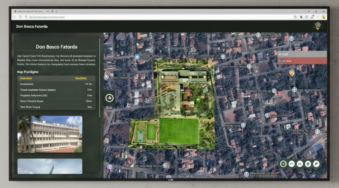
★
SpatialCraft Smart Interactive Digital Maps™ (SIDM™)
Your Project. Mapped. Connected. Continuously Updated.
Transform project maps and layout plans into an interactive digital representation of your project. Bring plot boundaries, terrain, elevation, and project information together in one online platform, enabling stakeholders to explore the project and support ongoing monitoring as it evolves.
Deliverables: Interactive 2D/3D maps, plot boundaries, GIS data layers, measurement tools, terrain visualisation, and project information layers, with options for progress-monitoring updates.
When to choose this service: When you need a continuously accessible digital view of your project to monitor progress, share information, and keep teams, clients, investors, and other stakeholders connected to the project as it develops.
Tech-Enabled Site Visualization Services
SpatialCraft Digital Mapping
SpatialCraft Smart Interactive Digital Maps™ (SIDM™)
Your Project. Mapped. Connected. Continuously Updated.
Transform project maps and layout plans into an interactive digital representation of your project. Bring plot boundaries, terrain, elevation, and project information together in one online platform, enabling stakeholders to explore the project and support ongoing monitoring as it evolves.
Deliverables: Interactive 2D/3D maps, plot boundaries, GIS data layers, measurement tools, terrain visualisation, and project information layers, with options for progress-monitoring updates.
When to choose this service: When you need a continuously accessible digital view of your project to monitor progress, share information, and keep teams, clients, investors, and other stakeholders connected to the project as it develops.
WhatsApp Call Us
★
SpatialCraft Smart Interactive Digital Maps™ (SIDM™)
Your Project. Mapped. Connected. Continuously Updated.
Transform project maps and layout plans into an interactive digital representation of your project. Bring plot boundaries, terrain, elevation, and project information together in one online platform, enabling stakeholders to explore the project and support ongoing monitoring as it evolves.
Deliverables: Interactive 2D/3D maps, plot boundaries, GIS data layers, measurement tools, terrain visualisation, and project information layers, with options for progress-monitoring updates.
When to choose this service: When you need a continuously accessible digital view of your project to monitor progress, share information, and keep teams, clients, investors, and other stakeholders connected to the project as it develops.