Sign Up & Login
Get started by signing in with your mobile number or email address.
If you think it’s not, then
you’re missing out.
Find your land parcel, check its details and explore property plans, all from one map-based platform.
Know what’s on the ground before you make your next move.
Owner: John Rodriguez
If you think it’s not, then
you’re missing out.
Find your land parcel, check its details and explore property plans, all from one map-based platform.
Know what’s on the ground before you make your next move.
Owner: John Rodriguez
Finding a property, identifying its survey number, understanding its boundaries, and accessing plot dimensions can be a time-consuming and frustrating process. People often depend on intermediaries, paperwork, and manual efforts just to get basic information about their land.

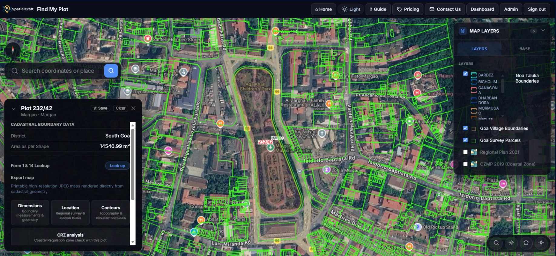
Find and download land information, maps and plans. All in one place, making property discovery simple and accessible.
Find My Plot makes it easy to explore a property, get the plans you need and reach out for professional assistance when you need more.
Get started by signing in with your mobile number or email address.
Enter a survey number or property location to find it on an interactive map and explore the property.
Access and download property maps, dimension plans, contour maps and location maps in just a few clicks.
Request additional services such as land surveys, property consultations and property document searches.
From finding a plot to getting professional assistance, everything starts with Find My Plot.
Find My Plot makes it easy to explore a property, get the plans you need and reach out for professional assistance when you need more.
Get started by signing in with your mobile number or email address.
Enter a survey number or property location to find it on an interactive map and explore the property.
Access and download property maps, dimension plans, contour maps and location maps in just a few clicks.
Request additional services such as land surveys, property consultations and property document searches.
From finding a plot to getting professional assistance, everything starts with Find My Plot.
Answers to common questions about Find My Plot. Still stuck? Email hello@spatialcraft.in.
Recently partitioned plots may not yet be reflected in the available records. Our platform displays data on an ‘as-is’ basis and is not a government portal. If you notice a missing update, contact our team for assistance. For the latest official records, please consult the relevant government land records portal, such as your state's Bhu Naksha portal.
No. Find My Plot is an independent platform developed by Spatialcraft, a private geospatial technology company. We provide advanced mapping and geospatial intelligence solutions across real estate, mining, environmental management, and governance, making land information more accessible to citizens.
No. The maps and information are intended for general reference and preliminary decision-making only. They are not a substitute for official land records, certified survey plans, or professional surveys. For legal matters, please consult the relevant government authorities and qualified professionals. Spatialcraft accepts no liability for decisions made solely on the basis of this information, to the extent permitted by law.
You can email us or call our designated support number for assistance.
Spatialcraft is a geospatial technology company working to make reliable location intelligence accessible and actionable. Our vision is to empower people, businesses, and governments with the spatial insights they need to make informed decisions about land, infrastructure, and the environment.
Find My Plot helps you locate survey parcels on an interactive map alongside satellite imagery. Using your mobile device, you can explore land parcels in relation to your current location, identify survey numbers, and access available parcel information and downloadable maps.
Our plans meet professional standards and are used by government departments, luxury real estate developers, and architects. Most clients have their own architects or engineers who review and validate our digital deliverables. If you require a hard-copy plan signed by a certified professional for approval submissions, we arrange this on request.
Please note: We generally do not undertake court-related or litigation work. If your requirement involves a legal dispute or court proceedings, please inform our consultant during the initial consultation.
Answers to common questions about Find My Plot. Still stuck? Email hello@spatialcraft.in.
Recently partitioned plots may not yet be reflected in the available records. Our platform displays data on an ‘as-is’ basis and is not a government portal. If you notice a missing update, contact our team for assistance. For the latest official records, please consult the relevant government land records portal, such as your state's Bhu Naksha portal.
No. Find My Plot is an independent platform developed by Spatialcraft, a private geospatial technology company. We provide advanced mapping and geospatial intelligence solutions across real estate, mining, environmental management, and governance, making land information more accessible to citizens.
No. The maps and information are intended for general reference and preliminary decision-making only. They are not a substitute for official land records, certified survey plans, or professional surveys. For legal matters, please consult the relevant government authorities and qualified professionals. Spatialcraft accepts no liability for decisions made solely on the basis of this information, to the extent permitted by law.
You can email us or call our designated support number for assistance.
Spatialcraft is a geospatial technology company working to make reliable location intelligence accessible and actionable. Our vision is to empower people, businesses, and governments with the spatial insights they need to make informed decisions about land, infrastructure, and the environment.
Find My Plot helps you locate survey parcels on an interactive map alongside satellite imagery. Using your mobile device, you can explore land parcels in relation to your current location, identify survey numbers, and access available parcel information and downloadable maps.
Our plans meet professional standards and are used by government departments, luxury real estate developers, and architects. Most clients have their own architects or engineers who review and validate our digital deliverables. If you require a hard-copy plan signed by a certified professional for approval submissions, we arrange this on request.
Please note: We generally do not undertake court-related or litigation work. If your requirement involves a legal dispute or court proceedings, please inform our consultant during the initial consultation.
We use cookies to provide you a better user experience on this website. Cookie Policy