
How aerial mapping and geospatial technology help large land investors understand the opportunity before committing substantial capital.
Imagine evaluating 100 acres of land. Or perhaps 1,000 acres spread across multiple land parcels, with different owners, varied terrain, existing structures, and complex planning constraints.
The title documents may be available. Site visits may be underway. But do you really know what you're acquiring?
Where exactly are the land outer line boundaries? What exists on the ground? Are there potential encroachments, gaps in between, difficult terrain, utilities like high tension lines, or proposed road alignments that could affect development? And how does the land's physical reality compare with the available government records?
For large land acquisitions, these questions can have significant financial consequences.
Yet investigating them presents its own challenge. A comprehensive physical ground survey across hundreds of acres can require substantial time, manpower, and resources, particularly where terrain is difficult or vegetation is dense. Committing to that level of detail before deciding whether to pursue the acquisition may not always make commercial sense.
The solution isn't to investigate less. It's to obtain the right information at the right stage.
The Technology Exists. Knowing What You Need At Each Project Stage Is the Challenge.
Aerial photogrammetry, LiDAR, Geographic Information Systems (GIS), and modern physical ground surveying each offer different ways to understand a property.
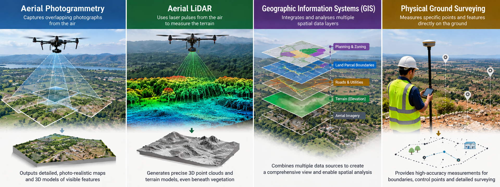
Photogrammetry reconstructs visible surfaces and features from aerial photographs. LiDAR uses laser measurements to capture three-dimensional information and can help map ground beneath vegetation where sufficient laser returns reach the surface. Ground surveying provides direct measurements for boundary verification, engineering, and other applications requiring specified accuracy.
These technologies can complement one another, but they aren't interchangeable. Each has different capabilities, costs, and limitations.
| Aerial Photogrammetry | Aerial LiDAR | GIS (Geographic Information Systems) | Physical Ground Surveying | |
|---|---|---|---|---|
| How it works | Uses overlapping aerial photographs | Uses laser pulses to collect 3D measurements | Integrates and analyses spatial data from multiple sources | Measures points and features directly on the ground |
| Main strength | Detailed imagery and mapping of visible features | Detailed 3D data and terrain mapping | Combines datasets to reveal spatial relationships and potential constraints | Direct measurements for verification and detailed surveys |
| Terrain & vegetation | Ground may be obscured by dense vegetation | May capture ground beneath vegetation, depending on conditions | Analyses terrain data from suitable source datasets | Requires field access to measure ground points |
| Typical outputs | Orthomosaic maps, surface models, 3D models | 3D point clouds, terrain models, contours | Integrated maps, spatial overlays, constraint analysis | Survey coordinates, control points, measured boundaries and elevations |
| Best suited for | Visual assessment and preliminary mapping of large areas | Areas where detailed terrain information or vegetation penetration is important | Land due diligence, parcel analysis, planning overlays and feasibility assessment | Ground verification, cadastral work and engineering surveys |
| Key consideration | Depends on image visibility and data quality | Performance depends on sensor, point density, vegetation and processing | Analysis depends on the accuracy and currency of input data | Time and resources depend on site access, coverage and required accuracy |
The question isn't which technology is best. It's which information you need to make your next decision.
At the preliminary acquisition stage, aerial land due diligence can provide a broad, structured understanding of a property before more extensive surveys are commissioned. If terrain or vegetation presents a particular challenge, LiDAR or an integrated LiDAR-photogrammetry workflow may be appropriate. If the acquisition proceeds to detailed planning and engineering, ground-validated surveys can then be undertaken to meet the project's requirements.
This staged approach helps investors direct their survey investment according to the decisions ahead.
What Does Aerial Land Due Diligence Actually Reveal?
At Spatialcraft, aerial land due diligence brings together high-resolution aerial mapping, terrain data - contours, GIS analysis, available land records, and planning information to build a more comprehensive understanding of the property.
Understand the property. Map the overall property and its constituent land parcels, overlay available government survey plans, and examine the relationship between recorded land boundaries as per government plans versus visible ground features. Potential discrepancies can be flagged for further ground verification and validation.
Identify existing features and potential encroachments. Map visible roads, structures, utilities, and other developments. Examine their locations with respect to property boundaries to identify issues requiring closer investigation.
Assess terrain and drainage characteristics. Use suitable elevation data, contours, and slope analysis to understand the site's topography and identify areas that may warrant further investigation for access, development, or drainage.
Examine planning constraints. Overlay relevant master plans, regional plans, zoning information, proposed road alignments, and road-widening proposals to understand how planning provisions may affect the property.
The value lies in bringing these different layers together. Instead of interpreting disconnected documents and isolated site observations, decision-makers gain a common spatial framework for evaluating the land, identifying potential risks, and determining where further investigation is necessary.
Spatialcraft also offers site overviews, immersive walkthroughs, and interactive digital maps, helping investors and project teams explore the property visually and understand where specific features or constraints lie within the larger landholding.
Better Information Before the Investment Decision
For investors, developers, project managers, and land acquisition teams, the value of aerial land due diligence goes far beyond better maps. It can help save significant time, money, and effort before a major investment decision is made.
Consider what a detailed ground survey of hundreds of acres can involve: mobilising field teams, arranging site access, navigating difficult terrain, and potentially clearing vegetation or disturbing the land and surrounding communities to collect the required data. Committing to this level of work before you are certain the acquisition will proceed can mean spending heavily on a property that may never become yours.
Aerial land due diligence offers a smarter starting point. By mapping the property and analysing available land records, visible features, terrain, and planning information early in the process, it can help uncover issues that might otherwise surface much later.
These findings can matter enormously at the negotiation table. A potential boundary deviation, a discrepancy between documented area and ground reality, an overlooked road alignment, or an existing development affecting the usable land could have significant financial implications. Depending on the circumstances, unresolved discrepancies can contribute to costly disputes, substantial losses, or years of litigation.
Identifying these issues early gives the acquisition team an opportunity to investigate further, reassess the opportunity, and negotiate with a clearer understanding of the risks—before committing substantial capital.
There is also value in what happens next. If the acquisition proceeds, the aerial due diligence investment is not simply discarded. Subject to data quality and project requirements, the information collected can provide a useful spatial baseline for subsequent surveys, planning, and development investigations. Detailed ground surveys can then be commissioned where they are actually needed.
If the acquisition does not proceed, the preliminary assessment may help avoid the time, cost, and effort of commissioning extensive detailed surveys for a project that was never going to move forward.
Importantly, aerial due diligence does not replace legal title verification, definitive cadastral boundary determination, statutory confirmation, or detailed engineering surveys where these are required. Instead, it helps decision-makers understand the property more comprehensively, uncover potential red flags, and determine what needs to be verified before proceeding.
At Spatialcraft, our approach is simple: use geospatial technology to help investors understand the land, identify the questions that matter, and direct further investigation where it is justified.
Before you invest crores in acres of property, understand the land beyond its paperwork.