
Land partition is rarely just about numbers.
On paper, dividing land by percentage looks straightforward. On the ground, it almost never is.
This project involved a land parcel of over 3,000 square meters, owned by one primary landowner and shared with four additional stakeholders. These stakeholders were mundkars (tenants) with legally defined percentage shares in the property.
The percentages were known.
What was not known was whether those percentages made sense on the ground.
Like in many such cases, all decisions were being discussed based on old records—records that had never been validated against current site conditions.
Where the Dispute Started
As soon as partition discussions began, basic but critical questions came up:
- Is the land area mentioned in the documents actually correct on site?
- From which part of the land will each person’s share be taken?
- What happens to existing tenant-built structures?
- Will surrounding encroachments be counted or ignored?
- How will access roads be provided after partition?
- Can the landowner retain a single, contiguous parcel with proper access?
These questions were never answered clearly in the past.
Once they were raised, tensions increased quickly.
Tenants were worried about losing access or having their built areas excluded.
The landowner was worried about ending up with fragmented land and compromised access.
Why the Traditional Survey Didn’t Help
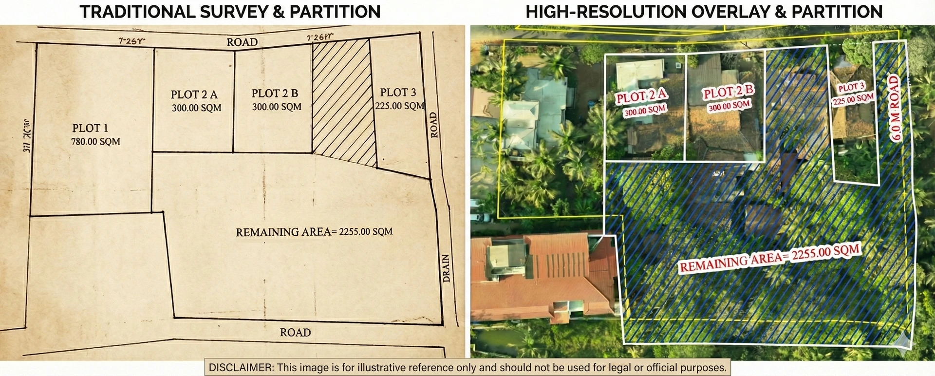
An attempt was made to resolve the issue using a conventional survey plan.
Instead of resolving the dispute, it made things worse.
Traditional survey drawings assume that all stakeholders can read and interpret technical plans. In this case, that assumption failed. The tenants could not visualize what the lines on paper actually meant on the land.
Each explanation led to more confusion.
Each clarification created more mistrust.
There was no shared understanding of what belongs where. As a result, discussions stalled.
That is when Spatialcraft was brought in.
The Real Cost of an Unresolved Partition
By the time Spatialcraft got involved, the dispute was already causing damage—much of it invisible.
1. Time Cost
- Multiple meetings without closure
- Repeated discussions going in circles
- Decisions delayed because no one agreed on ground reality
Land sitting idle quietly loses value.
2. Money Cost
Partition disputes create expenses that most owners underestimate:
- Legal consultations
- Repeat surveys and revisions
- Design changes due to unclear access
- Loss of usable land due to poor planning
Often, the cost of not getting clarity early is much higher than the cost of doing it right.
3. Effort Cost
- Repeated explanations to lawyers, tenants, and family members
- Multiple site visits with no conclusion
- Mental fatigue from constant uncertainty
This effort drains energy that could be used for planning or development.
4. Emotional Cost
This is the most underestimated cost:
- Fear of being short-changed
- Mistrust between parties
- Anxiety about future disputes
Once emotions take over, even fair solutions get rejected.
5. Risk Cost
An unclear partition creates long-term risk:
- Future disputes from heirs or successors
- Problems during sale or development
- Legal challenges years later
A settlement without clarity is not a solution—it is a postponed problem.
The Spatialcraft Approach: One Map, One Reality
Spatialcraft did not start by drawing partitions.
They started by validating reality.
Step 1: Ground Validation
- Physical boundaries were verified
- Actual land area was measured
- All existing structures and site features were mapped
Assumptions were removed. Facts were established.
Step 2: Visual Context
Instead of abstract drawings, all verified data was overlaid on a high-resolution aerial map.
For the first time, everyone could clearly see:
- What actually exists on the land
- Where boundaries truly lie
- How much usable area is available
No interpretation was required.
Step 3: Partition Scenarios
Using this single, verified map:
- Different partition options were explored
- Logical access roads were planned
- Tenant structures were accounted for
- The landowner’s portion remained contiguous and usable
Every option was visible. Every trade-off was clear.
How Conflict Turned into Agreement
Once all stakeholders were looking at the same verified map, the discussion changed.
- Tenants understood exactly what their share included
- The landowner had clarity on access and continuity
- Arguments reduced because decisions were based on facts, not assumptions
What started as a conflict-heavy partition became a practical, mutually acceptable settlement.
Why This Approach Matters
This method is not limited to tenant–landowner disputes.
It works for:
- Family inheritance partitions
- Long-standing property disagreements
- Pre-litigation settlements
- Any land decision involving multiple stakeholders
When everyone works from one shared, verified map, emotions reduce and decisions move forward.
The Takeaway
Most land disputes do not continue because solutions are unavailable.
They continue because ground reality is unclear.
By combining ground validation, aerial mapping, and visual clarity, Spatialcraft helped convert a stalled dispute into a clear decision.
In land matters, clarity is not optional.
It is what decides the outcome.