
The Challenge
A landowner approached Spatialcraft with a simple but critical problem:
He owned the land—but had no idea where his boundary actually lay on the ground.
There were:
❌ No fences
❌ No boundary stones
❌ No visible markers
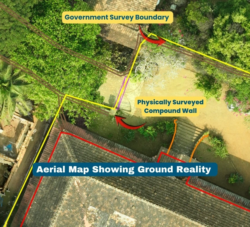
While the government survey plan existed on paper, there was nothing on-site to indicate:
where the boundary began,
where it ended, or
where boundary stones should be placed.
Any attempt to mark boundaries without proper validation risked:
incorrect placement,
objections from neighbours,
and future disputes.
Traditional demarcation methods—relying on isolated measurements and assumptions—would only create a temporary solution, not a defensible one.
The client did not want guesswork.
He wanted a boundary that would stand up to scrutiny today and years from now.
The Solution
Spatialcraft applied the Spatialcraft Standard for Property Boundary Demarcation, using the SpatialCraft Go-To Map (GTM) methodology.
Instead of starting with physical marking, Spatialcraft first established spatial truth.
The process followed a strict, non-negotiable sequence:
High-resolution aerial drone mapping to capture complete ground reality as it exists today
Georeferencing the entire site into an accurate spatial framework
Precisely overlaying the government survey plan onto the aerial map
Validating alignment between the official boundary shape and visible ground features
Only after validation, deploying a physical survey team to demarcate the boundary exactly as per government records, tied to verified coordinates
This ensured the boundary was not just marked—but anchored to a single, authoritative spatial dataset.
What Became Instantly Clear
Once everything was aligned on one map:
The boundary shape made logical sense on the ground
The area tallied accurately with official records
Minor deviations between physical features and the government plan became:
immediately visible,
clearly quantifiable,
and easy to explain
There was no ambiguity about why each boundary stone was placed where it was.
The demarcation was no longer subjective—it was spatially defensible.
The Results
The final outcome delivered clarity on multiple levels:
✔ Boundary stones placed at precisely georeferenced coordinates
✔ Demarcation aligned with government survey records and ground reality
✔ Neighbours satisfied due to clear visual and spatial reference
✔ Future disputes effectively prevented, not just managed
Most importantly, the boundary is now future-proof:
The client can revisit the exact coordinates at any time
Boundary points can be re-established even if stones are disturbed
All reference features remain documented within the same dataset
This transforms boundary demarcation from a one-time activity into a permanent spatial record.
Why This Sets a New Category Standard
Traditional boundary demarcation focuses on points.
The Spatialcraft Standard focuses on context.
By integrating:
Ground reality aerial mapping,
official government records,
and georeferenced physical boundary demarcation,
Spatialcraft ensures that:
every boundary is explainable,
every deviation is visible,
and every decision is defensible.
This is not just faster demarcation.
It is confident demarcation—built to prevent disputes before they arise.
Key Takeaway
When boundaries don’t exist on the ground, assumptions create disputes.
Georeferenced clarity prevents them.
That is why SpatialCraft Go-To Map (GTM)–based boundary demarcation is not just a service—it is the new standard for anyone who values certainty, credibility, and long-term peace of mind.